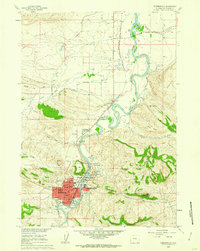
1960 Map of Thermopolis
USGS Topo · Published 1962About this map
Hot Springs State Park anchors the landscape along the Bighorn River, showcasing a concentration of geothermal features and early mid-century infrastructure. The park's famous mineral waters are marked by landmarks like Big Spring, Black Sulphur Spring, and the unique Rainbow Tepee Fountain, while the Devils Punch Bowl indicates the dramatic geology of the area.
Find a feature on this map
52 named features on this map. Tap any name to fly to it.
Don’t see what you’re looking for? This feature index may not catch every label — zoom into the map to look around manually.
Map Details
Editions of this 1960 Thermopolis Map
2 editions found
Other maps of this area

1914 · Blue Mesa
USGS Topo · 1:62,500

1916 · Blue Mesa
USGS Topo · 1:62,500

1945 · Kirby
USGS Topo · 1:62,500

1946 · Kirby
USGS Topo · 1:62,500

1955 · Thermopolis
USGS Topo · 1:250,000

1958 · Thermopolis
USGS Topo · 1:250,000

1960 · Devil Slide
USGS Topo · 1:24,000

1960 · Red Hole
USGS Topo · 1:24,000
1960 · Wedding Of The Waters
USGS Topo · 1:24,000

1960 · Thermopolis
USGS Topo · 1:24,000