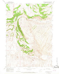
1965 Map of Nostrum Mountain
USGS Topo · Published 1968About this map
The Wind River Indian Reservation Boundary cuts through the western portion of this 1965 survey, marking the jurisdictional divide between the reservation and the surrounding Hot Springs County landscape. At the base of the prominent Nostrum Mountain and its sweeping Minnesela Slope, the Red Canyon Ranch is a primary point of human settlement, situated near the headwaters of Red Canyon Creek.
Find a feature on this map
17 named features on this map. Tap any name to fly to it.
Don’t see what you’re looking for? This feature index may not catch every label — zoom into the map to look around manually.
Map Details
Editions of this 1965 Nostrum Mountain Map
This is the sole edition of this map. No revisions or reprints were ever made.
Other maps of this area

1951 · Boysen
USGS Topo · 1:24,000

1951 · Mexican Pass
USGS Topo · 1:24,000

1951 · Morrison Canyon
USGS Topo · 1:24,000

1955 · Thermopolis
USGS Topo · 1:250,000

1958 · Thermopolis
USGS Topo · 1:250,000
1960 · Wedding Of The Waters
USGS Topo · 1:24,000

1960 · Thermopolis
USGS Topo · 1:24,000

1962 · Thermopolis
USGS Topo · 1:250,000
1965 · Potato Butte
USGS Topo · 1:24,000
1965 · Thompson Reservoirs
USGS Topo · 1:24,000