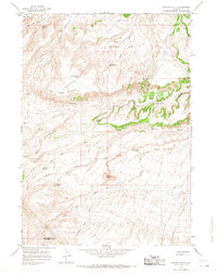
1965 Map of Potato Butte
USGS Topo · Published 1968About this map
The Wind River Indian Reservation landscape of the mid-1960s is defined by its complex drainage systems and isolated high ground, anchored by the prominent Potato Butte and the extensive Big Table Mountain. Water sources are the critical features in this arid environment, marked by numerous named springs such as Merrill Spring, Val Day Spring, and Rainwater Spring that fed the seasonal flows of Cottonwood Creek and Willow Creek.
Find a feature on this map
26 named features on this map. Tap any name to fly to it.
Don’t see what you’re looking for? This feature index may not catch every label — zoom into the map to look around manually.
Map Details
Editions of this 1965 Potato Butte Map
2 editions found
Other maps of this area

1951 · Mexican Pass
USGS Topo · 1:24,000

1951 · Morrison Canyon
USGS Topo · 1:24,000

1951 · Jenkins Mountain
USGS Topo · 1:24,000

1952 · Kates Basin
USGS Topo · 1:24,000

1955 · Thermopolis
USGS Topo · 1:250,000
1957 · Jenkins Mountain
USGS Topo · 1:24,000

1958 · Thermopolis
USGS Topo · 1:250,000

1962 · Thermopolis
USGS Topo · 1:250,000

1965 · Arapahoe Ranch
USGS Topo · 1:24,000
1965 · Nostrum Mountain
USGS Topo · 1:24,000