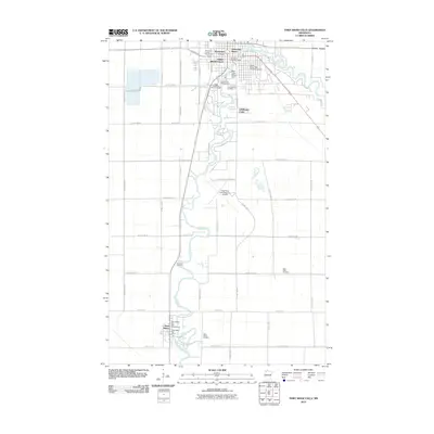
2010 Map of Thief River Falls
USGS Topo · Published 2010About this map
The Red Lake River meanders through the heart of this Pennington County landscape, providing the defining geographic feature for both Thief River Falls and the community of Saint Hilaire to the south. At the river's northern bend, the Red Lake River Dam and the Pennington County Fairgrounds mark the edge of the regional hub, while the Peder Engelstad Pioneer Village preserves local history near the Tourist Park Campground. The map reveals a transition from the urban density of the city, with residential developments like Greendale Manor and Basswood Court, to the surrounding agricultural plains. Local genealogy is well-served by several distinct burial sites, including Greenwood Cemetery, Riverside Cemetery, and the Saint Pauli Cemetery situated along the eastern rural corridors. Aviation infrastructure is a significant component of the area, represented by the expansive grounds of the Thief River Falls Regional Airport.
Find a feature on this map
50 named features on this map. Tap any name to fly to it.
Don’t see what you’re looking for? This feature index may not catch every label — zoom into the map to look around manually.
Map Details
Editions of this 2010 Thief River Falls Map
This is the sole edition of this map. No revisions or reprints were ever made.
Other maps of this area

1918 · Terrebonne
USGS Topo · 1:62,500

1918 · Red Lake Falls
USGS Topo · 1:62,500

1918 · Viking
USGS Topo · 1:62,500

1943 · Thief River Falls
USGS Topo · 1:62,500

1952 · Red Lake Falls
USGS Topo · 1:62,500

1952 · Grand Forks
USGS Topo · 1:250,000

1952 · Thief River Falls
USGS Topo · 1:250,000

1956 · Thief River Falls
USGS Topo · 1:250,000

1956 · Grand Forks
USGS Topo · 1:250,000

1957 · Thief River Falls
USGS Topo · 1:250,000
Featured Places
- Thief River Falls, MN
- St. Hilaire, MN
- Aaesby Trailer Court, MN
- Northside Trailer Park, St. Hilaire
- Saint Hilaire, St. Hilaire