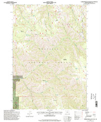
1995 Map of Thimbleberry Mountain
USGS Topo · Published 1998About this map
Umatilla National Forest encompasses the entirety of this topographic survey, defined by its complex network of ridges and water sources. The landscape is anchored by significant elevations including Thimbleberry Mountain, Huckleberry Mountain, and Black Mountain, which are separated by deep drainages like Dusty Saddle Canyon. Historically, the area shows evidence of fire watch and forest management at Goodman Lookout on Goodman Ridge. A distinct hydrological pattern emerges through the numerous named springs, such as Huckleberry Spring, Bear Camp Spring, and Shimmhorn Spr, which feed the headwaters of the South Fork Umatilla River and North Fork Meacham Creek. The Skyline Road provides the primary traverse across these heights, while the presence of the Base Line at the southern edge marks a fundamental surveying boundary for the Oregon-Umatilla region.
Find a feature on this map
38 named features on this map. Tap any name to fly to it.
Don’t see what you’re looking for? This feature index may not catch every label — zoom into the map to look around manually.
Map Details
Editions of this 1995 Thimbleberry Mountain Map
This is the sole edition of this map. No revisions or reprints were ever made.
Other maps of this area

1953 · Pendleton
USGS Topo · 1:250,000

1956 · Pendleton
USGS Topo · 1:250,000

1963 · Andies Prairie
USGS Topo · 1:24,000

1963 · Sanderson Spring
USGS Topo · 1:24,000

1963 · Bingham Springs
USGS Topo · 1:24,000

1963 · Summerville
USGS Topo · 1:24,000

1964 · Duncan
USGS Topo · 1:24,000

1964 · Thimbleberry Mtn
USGS Topo · 1:24,000

1964 · Gibbon
USGS Topo · 1:24,000

1964 · Huron
USGS Topo · 1:24,000