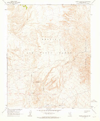
1962 Map of Thirsty Canyon SE
USGS Topo · Published 1963About this map
Nellis Air Force Range dominates this 1962 landscape in Nye County, Nevada, where the desert terrain is defined by complex contouring and a network of unimproved tracks. The map is a product of cooperation between the Geological Survey and the Atomic Energy Commission, reflecting the era's focus on national defense and scientific testing. In the southern half of the sheet, the Camp Transvaal (Site) marks a point of historical interest amidst the arid drainage of Beatty Wash. The topography transitions sharply as it moves toward the eastern edge, where the slopes of Timber Mountain rise from the basin. Traces of human activity are sparse, consisting primarily of the Military Reservation Boundary, a solitary Target, and various paths labeled as Jeep Trail, indicating a territory used more for strategic operations than permanent settlement.
Find a feature on this map
9 named features on this map. Tap any name to fly to it.
Don’t see what you’re looking for? This feature index may not catch every label — zoom into the map to look around manually.
Map Details
Editions of this 1962 Thirsty Canyon SE Map
2 editions found
Other maps of this area

1908 · Kawich
USGS Topo · 1:250,000

1908 · Furnace Creek
USGS Topo · 1:250,000

1910 · Furnace Creek
USGS Topo · 1:250,000

1942 · Tolicha Peak
USGS Topo · 1:125,000

1942 · Wheelbarrow Peak
USGS Topo · 1:125,000

1942 · Skull Mountain
USGS Topo · 1:125,000

1942 · Bullfrog
USGS Topo · 1:125,000

1948 · Death Valley
USGS Topo · 1:250,000

1952 · Topopah Spring
USGS Topo · 1:62,500

1952 · Timber Mountain
USGS Topo · 1:62,500