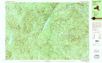
1990 Map of Thirteenth Lake
USGS Topo · Published 1990About this map
The high peaks and watercourses of the Adirondack Park define this interior wilderness at the intersection of Hamilton, Warren, and Essex Counties. Dominating the central landscape is Thirteenth Lake, its narrow profile framed by Big Thirteenth Lake Mountain and Little Thirteenth Lake Mountain. The terrain is remarkably dense with named summits like Gore Mountain and Bullhead Mountain, alongside an intricate network of ponds such as Botheration Pond and Puffer Pond. In the northeast corner, the Hudson River flows through the town of Chester, while the settlement of Sodom anchors the southeastern edge. This survey documents a complex hydrology where the headwaters of the Sacandaga River and Ruby Mountain Brook carve through steep elevation changes, providing a clear record of the backcountry trails and natural landmarks used by hunters and hikers in the late 20th century.
Find a feature on this map
87 named features on this map. Tap any name to fly to it.
Don’t see what you’re looking for? This feature index may not catch every label — zoom into the map to look around manually.
Map Details
Editions of this 1990 Thirteenth Lake Map
2 editions found
Other maps of this area

1895 · North Creek
USGS Topo · 1:62,500

1897 · North Creek
USGS Topo · 1:62,500

1897 · Schroon Lake
USGS Topo · 1:62,500

1898 · Newcomb
USGS Topo · 1:62,500

1898 · Thirteenth Lake
USGS Topo · 1:62,500

1899 · Indian Lake
USGS Topo · 1:62,500

1901 · Newcomb
USGS Topo · 1:62,500

1902 · Indian Lake
USGS Topo · 1:62,500

1903 · Blue Mountain
USGS Topo · 1:62,500

1950 · Glens Falls
USGS Topo · 1:250,000