1990 Map of Thirteenth Lake
USGS Topo · Published 1990About this map
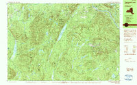
The Adirondack Park interior within the towns of Johnsburg, Indian Lake, and Minerva is defined by its high-elevation peaks and complex hydrography. The landscape is anchored by the prominent Gore Mountain and Bullhead Mountain, with drainage flowing through networks like the East Branch Sacandaga River and the upper reaches of the Hudson River. This 1990 survey captures a region primarily utilized for recreation and resource management rather than permanent settlement, evidenced by the prevalence of named water bodies such as Thirteenth Lake, Puffer Pond, and Chatiemac Lake. The presence of the Old Farm Road and the Botheration Pond Trail indicates the historical access routes used for timber or early mountain tourism. Small infrastructure features like the North Creek Reservoir point to the surrounding communities' reliance on these protected watersheds.
Find a feature on this map
86 named features on this map. Tap any name to fly to it.
Don’t see what you’re looking for? This feature index may not catch every label — zoom into the map to look around manually.
Map Details
Editions of this 1990 Thirteenth Lake Map
2 editions found
Other maps of this area

1895 · North Creek
USGS Topo · 1:62,500

1897 · North Creek
USGS Topo · 1:62,500

1897 · Schroon Lake
USGS Topo · 1:62,500

1898 · Newcomb
USGS Topo · 1:62,500

1898 · Thirteenth Lake
USGS Topo · 1:62,500

1899 · Indian Lake
USGS Topo · 1:62,500

1901 · Newcomb
USGS Topo · 1:62,500

1902 · Indian Lake
USGS Topo · 1:62,500

1903 · Blue Mountain
USGS Topo · 1:62,500

1950 · Glens Falls
USGS Topo · 1:250,000