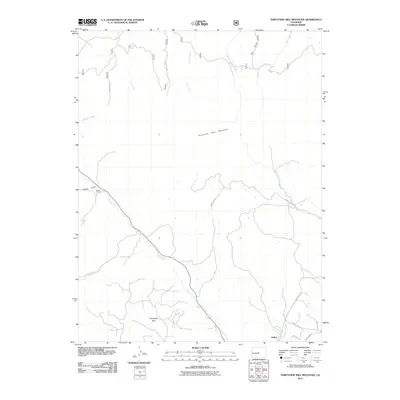
2011 Map of Thirtynine Mile Mountain
USGS Topo · Published 2011About this map
Thirtynine Mile Mountain dominates this high-altitude landscape in southern Park County, serving as the central topographical anchor for a complex network of drainage basins. To the south, the small community of Guffey sits at the intersection of local routes like County Rd 102 and County Rd 122, while the historic Wilson Ranch remains established near Sheep Gulch in the northwest. The drainage patterns revealed here show a divide where waters flow toward Currant Creek and Freshwater Creek, highlighting the importance of these seasonal and perennial water sources for ranching and settlement. Access to the high country is facilitated by a grid of Forest Service roads, including Forest Rd 253 and Forest Rd 270, which cut through the drainage of Pruden Creek and Union Creek. The map illustrates a transitional landscape where isolated mountain parks like Chumway Park provide flat acreage amidst the surrounding peaks.
Find a feature on this map
25 named features on this map. Tap any name to fly to it.
Don’t see what you’re looking for? This feature index may not catch every label — zoom into the map to look around manually.
Map Details
Editions of this 2011 Thirtynine Mile Mountain Map
This is the sole edition of this map. No revisions or reprints were ever made.
Other maps of this area

1894 · Pikes Peak
USGS Topo · 1:125,000

1901 · Pikes Peak
USGS Topo · 1:125,000

1942 · Cover Mtn.
USGS Topo · 1:62,500

1948 · Cover Mtn.
USGS Topo · 1:62,500

1954 · Pueblo
USGS Topo · 1:250,000

1956 · Elevenmile Canyon
USGS Topo · 1:24,000

1956 · Guffey NW
USGS Topo · 1:24,000

1956 · Spinney Mountain
USGS Topo · 1:24,000

1957 · Pueblo
USGS Topo · 1:250,000

1958 · Pueblo
USGS Topo · 1:250,000