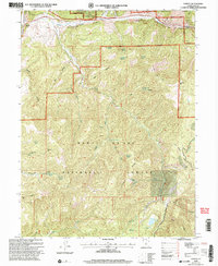
2001 Map of Thistle
USGS Topo · Published 2004About this map
Thistle (Site) marks a significant point of historical interest at the confluence of Spanish Fork and Thistle Creek, where the canyon landscape meets the edge of the Uinta National Forest. The topography is dominated by steep drainages like Wildcat Canyon and Blind Canyon, illustrating the challenging geography that historically influenced rail and road routes through this corridor. As the terrain ascends toward Sky High and Coffeepot Ridge, the map reveals a high-elevation network of water sources, including Jumpup Spring and Buggy Wheel Spring. The transition into the Manti-La Sal National Forest highlights the importance of the Sky High Trail for navigating these ridges. This 2001 revision documents the area's natural hydrology, featuring Smiths Reservoir and the restricted passage known as The Narrows, where Soldier Creek cuts through the rocky highlands.
Find a feature on this map
43 named features on this map. Tap any name to fly to it.
Don’t see what you’re looking for? This feature index may not catch every label — zoom into the map to look around manually.
Map Details
Editions of this 2001 Thistle Map
This is the sole edition of this map. No revisions or reprints were ever made.
Other maps of this area

1885 · Salt Lake
USGS Topo · 1:250,000

1885 · Manti
USGS Topo · 1:250,000

1895 · Manti
USGS Topo · 1:250,000

1907 · Strawberry Valley
USGS Topo · 1:125,000

1909 · Strawberry Valley
USGS Topo · 1:125,000

1949 · Provo
USGS Topo · 1:62,500

1949 · Spanish Fork Peak
USGS Topo · 1:24,000

1951 · Spanish Fork Peak
USGS Topo · 1:24,000

1952 · Santaquin Peak
USGS Topo · 1:62,500

1954 · Salt Lake City
USGS Topo · 1:250,000