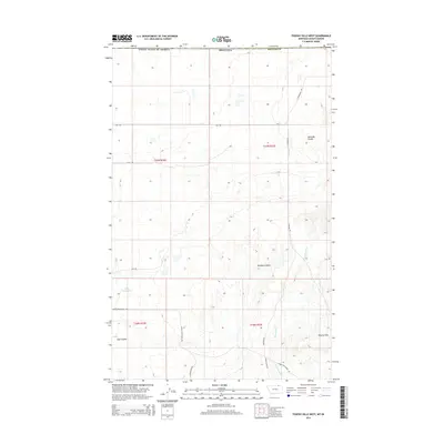
2014 Map of Thoeny Hills West
USGS Topo · Published 2014About this map
Thoeny Hills and the surrounding coulees of northern Phillips County define this high-plains landscape just south of the international border. The territory is characterized by its drainage patterns and water management features like Grog Reservoir and Cottonwood Cr, essential for ranching in this portion of the Montana-Saskatchewan frontier. Named coulees, including Kennedy Coulee, Dunham Coulee, and Voje Coulee, carve through the terrain, providing geographical landmarks in an area otherwise dominated by the public land survey grid. A network of rural routes such as Upper Frenchman Rd, Turkey Track Rd, and N Whitewater Rd connect the scattered homesteads and grazing lands, reflecting the enduring agricultural character of the region in the early 21st century.
Find a feature on this map
21 named features on this map. Tap any name to fly to it.
Don’t see what you’re looking for? This feature index may not catch every label — zoom into the map to look around manually.
Map Details
Editions of this 2014 Thoeny Hills West Map
This is the sole edition of this map. No revisions or reprints were ever made.
Other maps of this area

1920 · Cowan
USGS Topo · 1:125,000

1954 · Glasgow
USGS Topo · 1:250,000

1957 · Glasgow
USGS Topo · 1:250,000

1958 · Glasgow
USGS Topo · 1:250,000

1984 · Thoeny Hills East
USGS Topo · 1:24,000

1984 · Pea Lake
USGS Topo · 1:24,000

1984 · Whitewater East
USGS Topo · 1:24,000

1984 · Dead Horse Coulee
USGS Topo · 1:24,000
1984 · Thoeny Hills West
USGS Topo · 1:24,000
1984 · Salsbery Reservoir
USGS Topo · 1:24,000