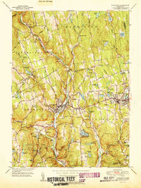
1951 Map of Thomaston
USGS Topo · Published 1951About this map
The Naugatuck River valley carves through this mid-century landscape, serving as a corridor for the New York New Haven and Hartford Railroad and anchoring settlements from Campville down to Reynolds Bridge. The industrial and municipal growth of the early 1950s is evident in the extensive reservoir systems serving Terryville and nearby towns, including Terryville Res No 3 and several numbered Bristol reservoirs. Away from the river, the terrain rises into clusters of family-named hills like Lattin Hill and Hickory Hill, where smaller hamlets such as Northfield and Town Hill maintain their character. Local history is deeply etched into the topography through numerous burial grounds like Hillside Cem and West Side Cem, alongside landmarks such as the Terryville Tunnel and the Mount Toby Airport, which reflect the era's evolving transportation and infrastructure needs.
Find a feature on this map
94 named features on this map. Tap any name to fly to it.
Don’t see what you’re looking for? This feature index may not catch every label — zoom into the map to look around manually.
Map Details
Editions of this 1951 Thomaston Map
2 editions found
Other maps of this area

1892 · Winsted
USGS Topo · 1:62,500

1892 · Meriden
USGS Topo · 1:62,500

1892 · Granby
USGS Topo · 1:62,500

1893 · Waterbury
USGS Topo · 1:62,500

1893 · Meriden
USGS Topo · 1:62,500

1904 · Waterbury
USGS Topo · 1:62,500

1904 · Litchfield
USGS Topo · 1:125,000

1906 · Farmington
USGS Topo · 1:125,000
1946 · Southington
USGS Topo · 1:31,680

1946 · Bristol
USGS Topo · 1:31,680