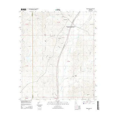
2015 Map of Thomastown
USGS Topo · Published 2015About this map
The Yockanookany River and Ninemile Creek define the drainage of this Leake County landscape, where the Natchez Trace Parkway and National Scenic Trail carves a long arc through the center of the quadrangle. This modern survey illustrates the persistent rural structure of the region, anchored by the community of Thomastown and the smaller settlement of Saint Ann. Family history and local heritage are well-preserved through numerous burial grounds, including the Thomastown Christian Cem, Thomastown Baptist Cem, and Damascus Cem. To the south, the terrain rises into the Government Hills, while a network of named local roads like Old Pickens Rd and Red Dog Rd connects the scattered homesteads. The map captures the meeting of Leake and Madison counties, marked by the flow of Rambo Cr and Risley Cr along the western boundary.
Find a feature on this map
75 named features on this map. Tap any name to fly to it.
Don’t see what you’re looking for? This feature index may not catch every label — zoom into the map to look around manually.
Map Details
Editions of this 2015 Thomastown Map
This is the sole edition of this map. No revisions or reprints were ever made.
Other maps of this area

1953 · Meridian
USGS Topo · 1:250,000

1957 · Meridian
USGS Topo · 1:250,000

1960 · Sharon
USGS Topo · 1:62,500

1961 · Carthage
USGS Topo · 1:62,500

1962 · Thomastown
USGS Topo · 1:62,500

1964 · Camden
USGS Topo · 1:24,000

1964 · Newport
USGS Topo · 1:24,000

1965 · Meridian
USGS Topo · 1:250,000
1966 · Goodman
USGS Topo · 1:62,500

1984 · Carthage
USGS Topo · 1:100,000