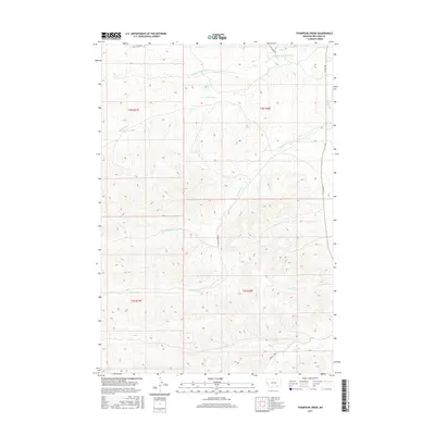
2017 Map of Thompson Creek
USGS Topo · Published 2017About this map
Rosebud Cr and its complex network of tributaries define the topography of this Big Horn County landscape. The drainage patterns of Thompson Cr, Little Thompson Cr, and Middle Fork Davis Cr carve through the terrain, illustrating the hydrologic character of the Montana plains. This 2017 U.S. Geological Survey representation documents a rural expanse primarily structured by these waterways and the sparse roadway system that follows them, including Reno Creek Rd and Thompson Crk Rd. The map provides a precise look at the Public Land Survey System divisions, such as t4s r38e and t5s r38e, which serve as the foundation for modern land ownership and property boundaries in the region. Local researchers can trace the course of smaller streams like Wolf Cr and Pine Cr as they feed into the larger creek systems.
Find a feature on this map
18 named features on this map. Tap any name to fly to it.
Don’t see what you’re looking for? This feature index may not catch every label — zoom into the map to look around manually.
Map Details
Editions of this 2017 Thompson Creek Map
This is the sole edition of this map. No revisions or reprints were ever made.
Other maps of this area

1894 · Rosebud
USGS Topo · 1:125,000

1901 · Rosebud
USGS Topo · 1:125,000

1954 · Hardin
USGS Topo · 1:250,000

1957 · Hardin
USGS Topo · 1:250,000

1958 · Hardin
USGS Topo · 1:250,000

1958 · Busby
USGS Topo · 1:24,000

1958 · Birdseye Spring
USGS Topo · 1:24,000

1967 · Wolf Mountain Lookout
USGS Topo · 1:24,000

1967 · Kirby
USGS Topo · 1:24,000
1967 · Jeans Fork SE
USGS Topo · 1:24,000