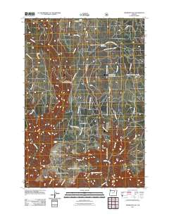
2011 Map of Thompson Flat
USGS Topo · Published 2011About this map
Thompson Flat sits at the heart of this backcountry landscape, where the high-altitude terrain is defined by a network of seasonal camps and water sources. The map reveals a remote working landscape used for livestock and forestry, centered on established points like the Thompson Corral and Juniper Camp. Drainage systems like Matlock Creek and Gilbert Creek carve through the plateau, leading toward notable landmarks such as Thompson Falls. Human presence is sparse but specific, marked by Florence Cabin and the Matlock Water Hole Camp. The intricate forest road system, including the Potamus Lookout Rd and Penland Prairie Rd, provides the primary access across these ridges, connecting remote overlooks like Potamus Point and the high vantage of Zion Scope.
Find a feature on this map
33 named features on this map. Tap any name to fly to it.
Don’t see what you’re looking for? This feature index may not catch every label — zoom into the map to look around manually.
Map Details
Editions of this 2011 Thompson Flat Map
This is the sole edition of this map. No revisions or reprints were ever made.
Other maps of this area

1950 · Ritter
USGS Topo · 1:62,500

1951 · Monument
USGS Topo · 1:62,500

1952 · Ritter
USGS Topo · 1:62,500

1953 · Pendleton
USGS Topo · 1:250,000

1955 · Canyon City
USGS Topo · 1:250,000

1956 · Pendleton
USGS Topo · 1:250,000

1959 · Canyon City
USGS Topo · 1:250,000

1969 · Lake Penland
USGS Topo · 1:24,000

1969 · Sugarbowl Creek
USGS Topo · 1:24,000

1969 · Deerhorn Creek
USGS Topo · 1:24,000