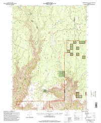
1995 Map of Thompson Flat
USGS Topo · Published 1998About this map
Thompson Flat sits at the high-elevation intersection of the Heppner Ranger District and the Morrow and Umatilla county line. This mid-1990s landscape within the Umatilla National Forest is defined by its water management and temporary forest settlements, such as Juniper Camp and Thompson Corral. The terrain is deeply incised by drainages like Potamus Creek and Ellis Creek, which drop away from the prominent Potamus Point. A notable concentration of exploration activity is evident through numerous Drill Holes scattered across the eastern plateaus. Water resources are critical in this upland environment, documented by a network of improved sites including Thompson Flat Well, Matlock Waterhole, and Divide Well. The southern edge of the map follows the National Forest Boundary, briefly touching the John Day River near the secluded Florence Cabin.
Find a feature on this map
39 named features on this map. Tap any name to fly to it.
Don’t see what you’re looking for? This feature index may not catch every label — zoom into the map to look around manually.
Map Details
Editions of this 1995 Thompson Flat Map
This is the sole edition of this map. No revisions or reprints were ever made.
Other maps of this area

1950 · Ritter
USGS Topo · 1:62,500

1951 · Monument
USGS Topo · 1:62,500

1952 · Ritter
USGS Topo · 1:62,500

1953 · Pendleton
USGS Topo · 1:250,000

1955 · Canyon City
USGS Topo · 1:250,000

1956 · Pendleton
USGS Topo · 1:250,000

1959 · Canyon City
USGS Topo · 1:250,000

1969 · Lake Penland
USGS Topo · 1:24,000

1969 · Sugarbowl Creek
USGS Topo · 1:24,000

1969 · Deerhorn Creek
USGS Topo · 1:24,000