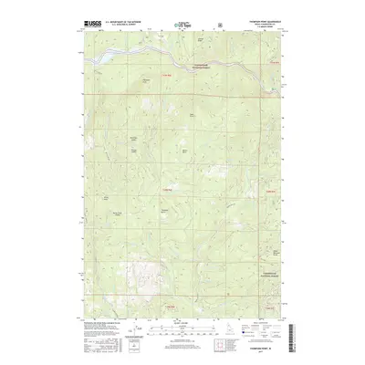
2017 Map of Thompson Point
USGS Topo · Published 2017About this map
The North Fork Clearwater River and the sprawling Dworshak Reservoir define the northern hydrology of this Clearwater County landscape. This 2017 survey details a high-elevation interior dominated by the Clearwater National Forest, where steep drainages like Thompson Cr and Beaver Cr carve through a series of named ridges and summits. Local landmarks include Thompson Point, Swan Point, and Micky Point, providing clear points of reference for navigating the terrain. For those interested in the passage of travel through the forest, the map identifies several strategic crossings including Kauffman Saddle, Hanson Saddle, and Butte Creek Saddle. The southern portion is anchored by the Sheep Mountain Range, while forest roads such as Butte Creek Rd and Beaver Creek Rd trace the rugged interior access network.
Find a feature on this map
49 named features on this map. Tap any name to fly to it.
Don’t see what you’re looking for? This feature index may not catch every label — zoom into the map to look around manually.
Map Details
Editions of this 2017 Thompson Point Map
This is the sole edition of this map. No revisions or reprints were ever made.
Other maps of this area

1923 · Washington Creek
USGS Topo · 1:125,000

1936 · Boehls Butte
USGS Topo · 1:48,000

1938 · Headquarters
USGS Topo · 1:48,000

1943 · Boehls Butte
USGS Topo · 1:62,500

1944 · Headquarters
USGS Topo · 1:62,500

1956 · Hamilton
USGS Topo · 1:250,000

1959 · Hamilton
USGS Topo · 1:250,000

1960 · Hamilton
USGS Topo · 1:250,000
1963 · Mallard Peak
USGS Topo · 1:24,000

1963 · Sheep Mtn
USGS Topo · 1:24,000