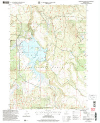
2004 Map of Thompson Reservoir
USGS Topo · Published 2007About this map
Thompson Reservoir dominates this high-altitude landscape within the Fremont National Forest, reflecting a mid-20th-century water management system for southern Oregon. The shoreline is marked by several seasonal drainages including Guyer Creek and Strawberry Creek, with a developed boat ramp indicating its role in local recreation. The map illustrates a rugged topography defined by significant elevations such as Brattain Ridge and Sycan Butte, which overlook the expansive Thompson Valley. Industrial activity is evident through multiple Cinder Pits and a Quarry near the Frog Ponds, likely supporting forest road maintenance. Small water sources like Tool Box Spring and Hawk Spring are scattered across the timbered terrain, serving as vital landmarks for those navigating the backcountry routes that traverse the Alder Spring Ridge and the Silver Creek drainage.
Find a feature on this map
27 named features on this map. Tap any name to fly to it.
Don’t see what you’re looking for? This feature index may not catch every label — zoom into the map to look around manually.
Map Details
Editions of this 2004 Thompson Reservoir Map
This is the sole edition of this map. No revisions or reprints were ever made.
Other maps of this area

1889 · Klamath
USGS Topo · 1:250,000

1894 · Klamath
USGS Topo · 1:250,000

1955 · Crescent
USGS Topo · 1:250,000

1955 · Klamath Falls
USGS Topo · 1:250,000

1957 · Crescent
USGS Topo · 1:250,000

1958 · Crescent
USGS Topo · 1:250,000

1958 · Klamath Falls
USGS Topo · 1:250,000

1960 · Sycan Marsh
USGS Topo · 1:62,500

1966 · Pole Butte
USGS Topo · 1:24,000

1966 · Foster Butte
USGS Topo · 1:24,000