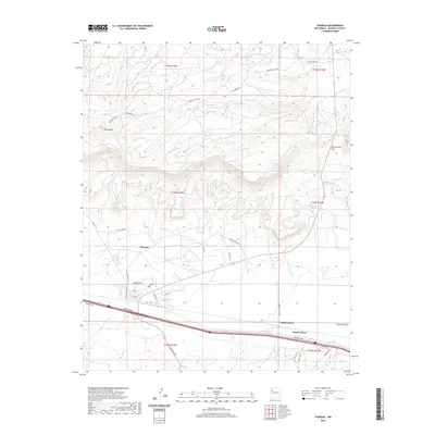
2020 Map of Thoreau
USGS Topo · Published 2020About this map
Thoreau stands as a central hub in McKinley County, where the high desert terrain meets the structured grid of a modern settlement. The landscape is defined by significant topographical landmarks like the prominent Mt Powell and the distinctive San Antonio Hill, while San Antonio Spring provides a vital water source in this arid environment. The map details a transition from the dense residential streets of Thoreau—including Frontier St, Lilac St, and Rose St—to the outlying communities of North Chaves and South Chaves. An extensive network of Indian Service Routes, such as Indian Svc Rte 50 and Indian Svc Rte 7018, alongside names like Largo S Corral Rd, points to the region's enduring ranching and transport history. The northern reaches are marked by rugged drainage patterns like Mitchell Draw, illustrating the complex natural drainage that dictates local land use.
Find a feature on this map
38 named features on this map. Tap any name to fly to it.
Don’t see what you’re looking for? This feature index may not catch every label — zoom into the map to look around manually.
Map Details
Editions of this 2020 Thoreau Map
This is the sole edition of this map. No revisions or reprints were ever made.
Other maps of this area

1886 · Wingate
USGS Topo · 1:250,000

1892 · Wingate
USGS Topo · 1:250,000

1954 · Gallup
USGS Topo · 1:250,000

1958 · Gallup
USGS Topo · 1:250,000

1959 · Gallup
USGS Topo · 1:250,000

1961 · Cottonwood Canyon
USGS Topo · 1:24,000

1962 · Gallup
USGS Topo · 1:250,000

1962 · Continental Divide
USGS Topo · 1:24,000

1962 · Cottonwood Canyon
USGS Topo · 1:24,000
1963 · Hosta Butte
USGS Topo · 1:24,000