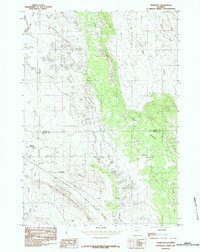
1984 Map of Thornton
USGS Topo · Published 1984About this map
The settlement of Thornton sits at the intersection of resource extraction and high plains topography along the Crook and Weston County line. This mid-1980s landscape is defined by its industrial activity, notably the prominent Oil Field to the west and several Bentonite Pits and Clay pits scattered near the Pine Ridge formation. These excavations reveal a heavy reliance on the region's geological deposits, while a series of modest water management features like Thornton Reservoir and Luman Reservoir provide critical infrastructure in a land marked by intermittent drainages such as Dry Draw and Wind Creek. The elevation shifts from the prominent Shale Hill to the wooded recesses of Sawmill Canyon, illustrating a transition between open range and the timbered breaks of the ridge.
Find a feature on this map
23 named features on this map. Tap any name to fly to it.
Don’t see what you’re looking for? This feature index may not catch every label — zoom into the map to look around manually.
Map Details
Editions of this 1984 Thornton Map
This is the sole edition of this map. No revisions or reprints were ever made.
Other maps of this area

1918 · Moorcroft
USGS Topo · 1:125,000

1918 · Moorcroft
USGS Topo · 1:62,500

1954 · Gillette
USGS Topo · 1:250,000

1955 · Gillette
USGS Topo · 1:250,000

1957 · Nefsy Divide
USGS Topo · 1:62,500

1957 · Moorcroft
USGS Topo · 1:62,500

1957 · Upton
USGS Topo · 1:62,500

1958 · Gillette
USGS Topo · 1:250,000

1962 · Gillette
USGS Topo · 1:250,000

1979 · Sundance
USGS Topo · 1:100,000