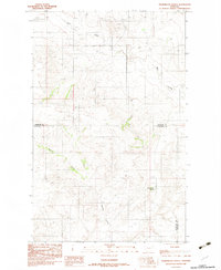
1983 Map of Thornwood Ranch
USGS Topo · Published 1983About this map
Wolf Creek meanders through the northern reaches of this northeastern Montana landscape, carved by the deep drainage patterns of the Missouri River watershed. This provisional survey highlights the rural character of the high plains in the early 1980s, where the boundary between Sheridan Co and Roosevelt Co bisects the terrain. The namesake Thornwood Ranch stands as a focal point for the area's agricultural history, situated near the headwaters of seasonal waterways. To the west, the distinct topography of Burshia Coulee defines the local relief, illustrating the erosion-carved breaks typical of this ranching country. The map provides a detailed view of the remote ranching infrastructure and natural drainage networks before modern updates, capturing a specific era of land use within the Fort Peck Indian Reservation.
Find a feature on this map
5 named features on this map. Tap any name to fly to it.
Don’t see what you’re looking for? This feature index may not catch every label — zoom into the map to look around manually.
Map Details
Editions of this 1983 Thornwood Ranch Map
This is the sole edition of this map. No revisions or reprints were ever made.
Other maps of this area

1909 · Smoke Creek
USGS Topo · 1:62,500

1912 · Smoke Creek
USGS Topo · 1:62,500

1914 · Homestead
USGS Topo · 1:62,500

1954 · Wolf Point
USGS Topo · 1:250,000

1958 · Wolf Point
USGS Topo · 1:250,000

1982 · Culbertson
USGS Topo · 1:100,000
1983 · Homestead NW
USGS Topo · 1:24,000

1983 · Kisler Butte
USGS Topo · 1:24,000
1983 · Flagstaff Hill
USGS Topo · 1:24,000
1983 · Smoke Creek NE
USGS Topo · 1:24,000