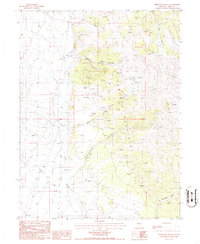
1986 Map of Three Bar Ranch
USGS Topo · Published 1986About this map
Three Bar Ranch serves as a central landmark in this high-desert landscape, situated where the Red Hills meet the rising slopes of the Roberts Mountains. The map reveals a region defined by its seasonal hydrology and prospecting history, with numerous prospects scattered through the steep drainages of Meadow Canyon and Jackass Canyon. Water management is evident along the alluvial fans, where Cots Creek, Cottonwood Creek, and Horse Creek descend toward a Gaging Station. This 1986 provisional survey captures the intersection of ranching operations and mineral exploration, documenting the network of springs like Jack Spring and remote canyons such as Dry Canyon that supported life and industry in this portion of Eureka County.
Find a feature on this map
16 named features on this map. Tap any name to fly to it.
Don’t see what you’re looking for? This feature index may not catch every label — zoom into the map to look around manually.
Map Details
Editions of this 1986 Three Bar Ranch Map
This is the sole edition of this map. No revisions or reprints were ever made.
Other maps of this area

1926 · Roberts Mountains
USGS Topo · 1:250,000

1929 · Roberts Mountains
USGS Topo · 1:250,000

1949 · Roberts Creek Mtn
USGS Topo · 1:62,500

1951 · Roberts Creek Mtn
USGS Topo · 1:62,500

1955 · Millett
USGS Topo · 1:250,000

1956 · Bartine Ranch
USGS Topo · 1:62,500

1956 · Walti Hot Springs
USGS Topo · 1:62,500

1956 · Ackerman Canyon
USGS Topo · 1:62,500

1959 · Millett
USGS Topo · 1:250,000

1979 · Simpson Park Mtns
USGS Topo · 1:100,000