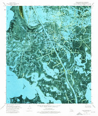
1973 Map of Three Bayou Bay
USGS Topo · Published 1976About this map
The Barataria Oil and Gas Field dominates this Jefferson Parish landscape, where industrial infrastructure meets the complex hydrology of the Mississippi River Delta. This orthophotomap, derived from 1971 aerial photography, reveals the pervasive network of oil wells, drill holes, and offshore platforms that define the local economy. Navigational channels like the Barataria Bay Waterway and Dupre Cut provide straight-line transit through a labyrinth of natural marshland and open water, including Three Bayou Bay and Turtle Bay. The presence of the Texaco Heliport underscores the logistical demands of offshore and marshland energy extraction during the early 1970s. While human intervention is visible through a series of dams and pipelines, the map also documents the meandering natural paths of Bayou Rigolettes and Bayou St Denis as they flow toward the Gulf.
Find a feature on this map
18 named features on this map. Tap any name to fly to it.
Don’t see what you’re looking for? This feature index may not catch every label — zoom into the map to look around manually.
Map Details
Editions of this 1973 Three Bayou Bay Map
This is the sole edition of this map. No revisions or reprints were ever made.
Other maps of this area

1891 · Pointe a La Hache
USGS Topo · 1:62,500

1892 · Barataria
USGS Topo · 1:62,500

1892 · Creole
USGS Topo · 1:62,500

1892 · Pointe a La Hache
USGS Topo · 1:62,500

1893 · Fort Livingston
USGS Topo · 1:62,500

1935 · Wilkinson Bay
USGS Topo · 1:31,680

1939 · Pointe a La Hache
USGS Topo · 1:62,500

1941 · Barataria
USGS Topo · 1:62,500

1944 · Barataria
USGS Topo · 1:62,500
1944 · Pointe a La Hache
USGS Topo · 1:62,500