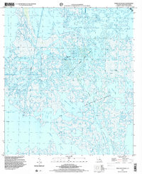
1998 Map of Three Bayou Bay
USGS Topo · Published 2001About this map
The extensive marshlands and water bodies of Jefferson Parish are dominated by the infrastructure of the energy industry in the late 1990s. The Lafitte Oil and Gas Field and the Three Bayou Oil and Gas Field define the human footprint on this landscape, characterized by numerous drill holes, platforms, and pipelines. Marine transportation is facilitated by the Barataria Bay Waterway and the Dupre Cut, providing essential routes through the complex network of Three Bayou Bay and Turtle Bay. Small settlements or outposts like Cutler and Maurice are situated along the winding paths of Bayou Cutler and Maurice Bayou, reflecting a way of life deeply tied to the coastal Louisiana environment. The presence of the Texaco Heliport serves as a reminder of the logistical coordination required to manage these offshore and marsh-based operations.
Find a feature on this map
24 named features on this map. Tap any name to fly to it.
Don’t see what you’re looking for? This feature index may not catch every label — zoom into the map to look around manually.
Map Details
Editions of this 1998 Three Bayou Bay Map
This is the sole edition of this map. No revisions or reprints were ever made.
Other maps of this area

1891 · Pointe a La Hache
USGS Topo · 1:62,500

1892 · Barataria
USGS Topo · 1:62,500

1892 · Creole
USGS Topo · 1:62,500

1892 · Pointe a La Hache
USGS Topo · 1:62,500

1893 · Fort Livingston
USGS Topo · 1:62,500

1935 · Wilkinson Bay
USGS Topo · 1:31,680

1939 · Pointe a La Hache
USGS Topo · 1:62,500

1941 · Barataria
USGS Topo · 1:62,500

1944 · Barataria
USGS Topo · 1:62,500
1944 · Pointe a La Hache
USGS Topo · 1:62,500