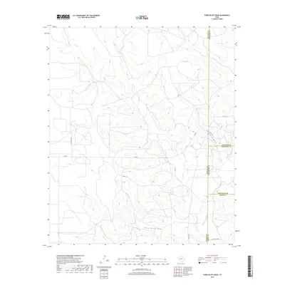
2019 Map of Three Bluff Draw
USGS Topo · Published 2019About this map
The Middle Concho River and its seasonal drainages define this West Texas landscape where the borders of Tom Green, Reagan, Sterling, and Irion counties meet. The topography is dominated by the deep incisions of Three Bluff Draw and Hackberry Draw, which channel runoff across the arid Edwards Plateau toward the Concho basin. These draws serve as natural corridors through the high ground, influencing the placement of local thoroughfares like FM 2600 and Cope Rd. Ranching heritage is evidenced by family-named landmarks and private access points such as Holt Ranch Rd and Momma Pfluger Rd. The drainage network includes Indian Cr and Corral Cr, which intersect the undulating terrain, providing a look at the geographic isolation and specialized land use in this specific corner of the Concho Valley.
Find a feature on this map
18 named features on this map. Tap any name to fly to it.
Don’t see what you’re looking for? This feature index may not catch every label — zoom into the map to look around manually.
Map Details
Editions of this 2019 Three Bluff Draw Map
This is the sole edition of this map. No revisions or reprints were ever made.
Other maps of this area

1921 · Ketchum Mountain
USGS Topo · 1:62,500

1923 · Ketchum Mountain
USGS Topo · 1:62,500

1954 · San Angelo
USGS Topo · 1:250,000

1958 · San Angelo
USGS Topo · 1:250,000

1965 · San Angelo
USGS Topo · 1:250,000

1970 · South Mustang Draw NE
USGS Topo · 1:24,000

1970 · Moore Hill
USGS Topo · 1:24,000

1973 · Hay Hollow
USGS Topo · 1:24,000

1973 · Three Bluff Draw
USGS Topo · 1:24,000

1973 · Three Bluff Draw NE
USGS Topo · 1:24,000