
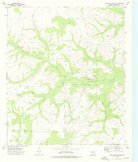
1973 Map of Three Bluff Draw
USGS Topo · Published 1976About this map
The rugged intersection of several West Texas counties comes into focus in this early 1970s survey, where Reagan, Sterling, Tom Green, and Irion counties meet. The landscape is defined by the ephemeral drainage systems of the Concho River watershed, including Hackberry Draw, Tristan Creek, and the prominent Three Bluff Draw. This era marks a significant period of energy exploration and resource extraction in the Permian Basin, evidenced by the extensive oil and gas infrastructure throughout Cope Field. Isolated ranching outposts like Lone Joe Ranch sit among a network of unimproved roads and numerous gravel pits, illustrating the sparse but industrial character of the plains. Trace the early development of local petroleum fields and the persistent cattle ranching footprint that has long characterized this portion of the Edwards Plateau.
Find a feature on this map
14 named features on this map. Tap any name to fly to it.
Don’t see what you’re looking for? This feature index may not catch every label — zoom into the map to look around manually.
Map Details
Editions of this 1973 Three Bluff Draw Map
This is the sole edition of this map. No revisions or reprints were ever made.
Other maps of this area

1921 · Ketchum Mountain
USGS Topo · 1:62,500

1923 · Ketchum Mountain
USGS Topo · 1:62,500

1954 · San Angelo
USGS Topo · 1:250,000

1958 · San Angelo
USGS Topo · 1:250,000

1965 · San Angelo
USGS Topo · 1:250,000

1970 · South Mustang Draw NE
USGS Topo · 1:24,000

1970 · Moore Hill
USGS Topo · 1:24,000

1973 · Hay Hollow
USGS Topo · 1:24,000

1973 · Three Bluff Draw NE
USGS Topo · 1:24,000
1973 · Coon Dive Draw NW
USGS Topo · 1:24,000