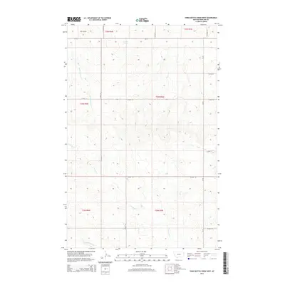
2014 Map of Three Buttes Creek West
USGS Topo · Published 2014About this map
Three Buttes Creek flows through this corner of Richland County, where the high plains terrain is defined by an intricate network of coulees and seasonal drainages. The landscape is characterized by its drainage patterns, with Antelope Springs and Middle Charlie Cr marking the north, while the southern reaches are dominated by E Fork Fox Cr and Middle Fork Fox Cr. This survey illustrates the organized grid of the Public Land Survey System, showing the intersection of townships T24N and T25N. A series of county roads, including Co Road 324 and Co Road 133, follow these section lines, providing a clear picture of the rural infrastructure and land divisions that have shaped ranching and agriculture in this part of Montana.
Find a feature on this map
21 named features on this map. Tap any name to fly to it.
Don’t see what you’re looking for? This feature index may not catch every label — zoom into the map to look around manually.
Map Details
Editions of this 2014 Three Buttes Creek West Map
This is the sole edition of this map. No revisions or reprints were ever made.
Other maps of this area

1909 · Glendive
USGS Topo · 1:250,000

1954 · Glendive
USGS Topo · 1:250,000

1957 · Glendive
USGS Topo · 1:250,000

1958 · Glendive
USGS Topo · 1:250,000

1972 · Fox Lake
USGS Topo · 1:24,000

1972 · Lambert
USGS Topo · 1:24,000

1972 · Enid
USGS Topo · 1:24,000

1981 · Sidney
USGS Topo · 1:100,000
1983 · Elmdale
USGS Topo · 1:24,000
1983 · Carda Coulee
USGS Topo · 1:24,000