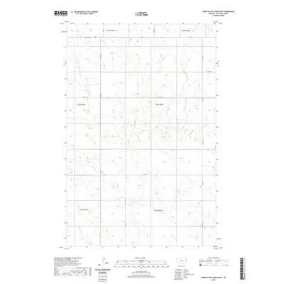
2020 Map of Three Buttes Creek West
USGS Topo · Published 2020About this map
Antelope Springs marks a rare water source in this high-plains landscape of Richland County, where the terrain is defined by the complex drainage systems of the Missouri River plateau. The area is characterized by deep coulees and seasonal stream beds, including the winding course of Middle Charlie Cr in the northwest and the branching headwaters of E Fork Fox Cr and Middle Fork Fox Cr to the south. This 2020 edition preserves the traditional Public Land Survey System divisions, showing the township and range lines for T25N through T23N. A sparse network of county roads, such as Co RD 324 and Co RD 133, provides access to these remote ranchlands, following the natural contours of the breaks and ridges near Elm Coulee.
Find a feature on this map
17 named features on this map. Tap any name to fly to it.
Don’t see what you’re looking for? This feature index may not catch every label — zoom into the map to look around manually.
Map Details
Editions of this 2020 Three Buttes Creek West Map
This is the sole edition of this map. No revisions or reprints were ever made.
Other maps of this area

1909 · Glendive
USGS Topo · 1:250,000

1954 · Glendive
USGS Topo · 1:250,000

1957 · Glendive
USGS Topo · 1:250,000

1958 · Glendive
USGS Topo · 1:250,000

1972 · Fox Lake
USGS Topo · 1:24,000

1972 · Lambert
USGS Topo · 1:24,000

1972 · Enid
USGS Topo · 1:24,000

1981 · Sidney
USGS Topo · 1:100,000
1983 · Elmdale
USGS Topo · 1:24,000
1983 · Carda Coulee
USGS Topo · 1:24,000