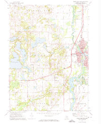
1972 Map of Three Rivers West
USGS Topo · Published 1974About this map
Three Rivers sits at the confluence of several major waterways, including the Portage River, Rocky River, and the St Joseph River. This 1970s landscape reveals a concentrated urban center with established neighborhoods along Walnut St and Michigan Ave, contrasted by the glaciated lake country to the west. The western portion of the map is defined by a dense cluster of water bodies like Pleasant Lake, Corey Lake, and Kaiser Lake, which supported early community centers such as the Lake Section Community School. Further north, the Dutch Settlement area represents the rural agricultural character of Flowerfield township. Local industry and transit are evident through the Penn Central rail line and numerous Gravel Pits, while legacy landmarks like Flatbush Cem and Hoffman School provide essential data for tracing family roots in St. Joseph County.
Find a feature on this map
89 named features on this map. Tap any name to fly to it.
Don’t see what you’re looking for? This feature index may not catch every label — zoom into the map to look around manually.
Map Details
Editions of this 1972 Three Rivers West Map
2 editions found
Other maps of this area

1914 · Three Rivers
USGS Topo · 1:62,500

1916 · Three Rivers
USGS Topo · 1:62,500

1922 · Schoolcraft
USGS Topo · 1:62,500

1943 · Three Rivers
USGS Topo · 1:62,500

1943 · Schoolcraft
USGS Topo · 1:62,500

1944 · Marcellus
USGS Topo · 1:62,500

1946 · Marcellus
USGS Topo · 1:62,500

1948 · Vandalia
USGS Topo · 1:62,500

1949 · Vandalia
USGS Topo · 1:62,500

1953 · Fort Wayne
USGS Topo · 1:250,000