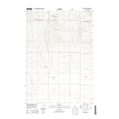
2013 Map of Thunder Gulch
USGS Topo · Published 2013About this map
Targhee National Forest dominates this high-altitude landscape in Clark County, characterized by a complex drainage network that defines the region's topography. The namesake Thunder Gulch carves through the southern portion of the sheet, served by the eponymous Thunder Gulch Rd. This area is a critical watershed where numerous streams, including Lava Cr, Cow Cr, and the various branches of Cottonwood Cr, descend from the timbered heights toward the valley floor.
Find a feature on this map
27 named features on this map. Tap any name to fly to it.
Don’t see what you’re looking for? This feature index may not catch every label — zoom into the map to look around manually.
Map Details
Editions of this 2013 Thunder Gulch Map
This is the sole edition of this map. No revisions or reprints were ever made.
Other maps of this area

1955 · Dubois
USGS Topo · 1:250,000

1957 · Paul Reservoir
USGS Topo · 1:62,500

1958 · Dubois
USGS Topo · 1:250,000

1964 · Dubois NW
USGS Topo · 1:24,000

1964 · Lone Butte
USGS Topo · 1:24,000

1964 · Small
USGS Topo · 1:24,000

1972 · Spencer South
USGS Topo · 1:24,000

1972 · Spencer North
USGS Topo · 1:24,000

1983 · Dubois
USGS Topo · 1:100,000
1987 · Thunder Gulch
USGS Topo · 1:24,000