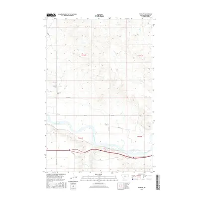
2017 Map of Thurlow
USGS Topo · Published 2017About this map
Thurlow occupies a significant bend in the Yellowstone River, marking a point where early ranching and transport infrastructure met the high plains of Rosebud County. This 2017 survey shows the enduring geography of the river bottomlands, where the modern interstate corridor follows the historical path of Old US Hwy 10 and Frontage Rd. The landscape north of the river is defined by a dense network of intermittent drainages including Goose Cr, Bull Cr, and Sand Cr, which cut through the high ground. Local landmarks such as Jack Creek Hill and the Sand Creek Bridge indicate the established rural road system, while the township and range lines of t7n r43e and t6n r43e provide a clear grid for tracing land ownership and historical property boundaries in this Montana river valley.
Find a feature on this map
22 named features on this map. Tap any name to fly to it.
Don’t see what you’re looking for? This feature index may not catch every label — zoom into the map to look around manually.
Map Details
Editions of this 2017 Thurlow Map
This is the sole edition of this map. No revisions or reprints were ever made.
Other maps of this area

1954 · Forsyth
USGS Topo · 1:250,000

1957 · Forsyth
USGS Topo · 1:250,000

1958 · Forsyth
USGS Topo · 1:250,000

1968 · Rosebud
USGS Topo · 1:24,000

1968 · Box Canyon Coulee
USGS Topo · 1:24,000

1968 · Sand Buttes
USGS Topo · 1:24,000

1968 · Hathaway
USGS Topo · 1:24,000

1968 · Hathaway NW
USGS Topo · 1:24,000

1968 · Thurlow
USGS Topo · 1:24,000
1969 · Miller Creek NW
USGS Topo · 1:24,000