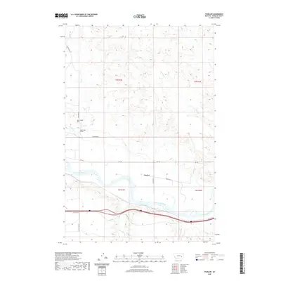
2020 Map of Thurlow
USGS Topo · Published 2020About this map
The Yellowstone River cuts a wide path through this Rosebud County landscape, anchoring the small settlement of Thurlow. The river valley is a hub of transportation and water management, featuring the Cartersville Canal running parallel to the north bank and the Sand Creek Bridge spanning a major northern tributary. The terrain rises toward the north to Jack Creek Hill, while the southern reaches are defined by the drainage of Sweeney Cr and remnants of the regional road network including Old US Hwy 10. This 2020 survey illustrates how modern infrastructure, such as Hwy 446 and various ranch roads like Sand Creek Rd, overlays the historical river-bottom settlement patterns of the Big Sky Country.
Find a feature on this map
22 named features on this map. Tap any name to fly to it.
Don’t see what you’re looking for? This feature index may not catch every label — zoom into the map to look around manually.
Map Details
Editions of this 2020 Thurlow Map
This is the sole edition of this map. No revisions or reprints were ever made.
Other maps of this area

1954 · Forsyth
USGS Topo · 1:250,000

1957 · Forsyth
USGS Topo · 1:250,000

1958 · Forsyth
USGS Topo · 1:250,000

1968 · Rosebud
USGS Topo · 1:24,000

1968 · Box Canyon Coulee
USGS Topo · 1:24,000

1968 · Sand Buttes
USGS Topo · 1:24,000

1968 · Hathaway
USGS Topo · 1:24,000

1968 · Hathaway NW
USGS Topo · 1:24,000

1968 · Thurlow
USGS Topo · 1:24,000
1969 · Miller Creek NW
USGS Topo · 1:24,000