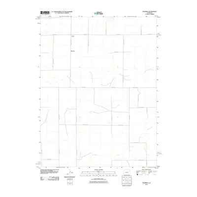
2010 Map of Thurman
USGS Topo · Published 2010About this map
Thurman sits within the high plains of Washington County, a small settlement defined by a strict grid of section-line roads. This 2010 survey shows the community's quiet footprint, centered near the intersection of County Road CC and County Rd-2. The landscape is etched by the meandering course of the North Fork Arikaree River, which flows through the northern half of the area, while the main Arikaree River cuts across the southern portion. For those researching local families, the Thurman Cemetery is clearly marked to the north of the main settlement. The map provides a detailed view of the rural infrastructure of the early 21st century, where life revolves around these ephemeral waterways and the vast network of gravel routes like County Rd-3 and County Rd-1 that tie the agricultural parcels together.
Find a feature on this map
24 named features on this map. Tap any name to fly to it.
Don’t see what you’re looking for? This feature index may not catch every label — zoom into the map to look around manually.
Map Details
Editions of this 2010 Thurman Map
This is the sole edition of this map. No revisions or reprints were ever made.
Other maps of this area

1954 · Limon
USGS Topo · 1:250,000

1957 · Limon
USGS Topo · 1:250,000

1958 · Limon
USGS Topo · 1:250,000

1973 · Lindon NE
USGS Topo · 1:24,000

1973 · Shaw
USGS Topo · 1:24,000

1977 · Thurman
USGS Topo · 1:24,000

1977 · Arickaree
USGS Topo · 1:24,000

1977 · Anton SE
USGS Topo · 1:24,000
1978 · Anton
USGS Topo · 1:24,000

1979 · Flagler NW
USGS Topo · 1:24,000