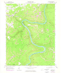
1969 Map of Thurmond
USGS Topo · Published 1977About this map
The New River carves a deep, winding path through this West Virginia coal country, dictating the placement of railroads and industrial settlements. The Chesapeake and Ohio railroad line snakes along the riverbanks, connecting coal-loading hubs like Thurmond and Stone Cliff. This era shows a landscape heavily shaped by extraction, with numerous strip mines dotting the highlands of Garden Ground Mountain and Pea Ridge. Large industrial features like the mine conveyor tipple and various air shafts illustrate the underground infrastructure supporting the region's economy.
Find a feature on this map
63 named features on this map. Tap any name to fly to it.
Don’t see what you’re looking for? This feature index may not catch every label — zoom into the map to look around manually.
Map Details
Editions of this 1969 Thurmond Map
3 editions found
Other maps of this area

1887 · Hinton
USGS Topo · 1:125,000

1889 · Nicholas
USGS Topo · 1:125,000

1891 · Nicholas
USGS Topo · 1:125,000

1891 · Raleigh
USGS Topo · 1:125,000

1892 · Hinton
USGS Topo · 1:125,000

1897 · Kanawha Falls
USGS Topo · 1:125,000

1897 · Raleigh
USGS Topo · 1:125,000

1900 · Kanawha Falls
USGS Topo · 1:125,000

1901 · Nicholas
USGS Topo · 1:125,000

1901 · Kanawha Falls
USGS Topo · 1:125,000