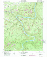
1969 Map of Thurmond
USGS Topo · Published 1989About this map
The New River Gorge National River defines the landscape of this 1960s survey, illustrating a deep river canyon carved through the plateau. At the center of this industrial corridor lies Thurmond, a vital rail hub where 3 Tracks navigate the narrow riverbanks. This era captures the intensive coal and mineral extraction that shaped Fayette County, visible through a dense network of strip mines, mine dumps, and several conveyor tipples used for loading materials from the heights of Garden Ground Mountain down to the rail lines.
Find a feature on this map
68 named features on this map. Tap any name to fly to it.
Don’t see what you’re looking for? This feature index may not catch every label — zoom into the map to look around manually.
Map Details
Editions of this 1969 Thurmond Map
3 editions found
Other maps of this area

1887 · Hinton
USGS Topo · 1:125,000

1889 · Nicholas
USGS Topo · 1:125,000

1891 · Nicholas
USGS Topo · 1:125,000

1891 · Raleigh
USGS Topo · 1:125,000

1892 · Hinton
USGS Topo · 1:125,000

1897 · Kanawha Falls
USGS Topo · 1:125,000

1897 · Raleigh
USGS Topo · 1:125,000

1900 · Kanawha Falls
USGS Topo · 1:125,000

1901 · Nicholas
USGS Topo · 1:125,000

1901 · Kanawha Falls
USGS Topo · 1:125,000