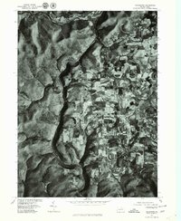
1977 Map of Tiadaghton
USGS Topo · Published 1979About this map
Pine Creek carves a deep, winding path through the landscape of Tioga County, defining the western portion of this orthophotoquad. This unique perspective, derived from 1977 aerial photography, reveals the stark contrast between the steep, wooded slopes bordering the water and the high plateau farmland to the east. Small rural settlements like Dexter and Kennedy appear as tight clusters of structures along established roads, surrounded by a patchwork of agricultural fields. This 1970s snapshot captures the rural economy of the region before modern development patterns significantly altered the footprint of these historic crossroads. The imagery provides an unmistakable record of field boundaries, forest cover, and the precise siting of homes and barns in Olmsville and Tiadaghton, offering genealogists and land historians a clear view of the terrain as it existed late in the century.
Find a feature on this map
5 named features on this map. Tap any name to fly to it.
Don’t see what you’re looking for? This feature index may not catch every label — zoom into the map to look around manually.
Map Details
Editions of this 1977 Tiadaghton Map
This is the sole edition of this map. No revisions or reprints were ever made.
Other maps of this area

1899 · Gaines
USGS Topo · 1:62,500

1900 · Gaines
USGS Topo · 1:62,500

1900 · Elkland
USGS Topo · 1:62,500

1946 · Tiadaghton
USGS Topo · 1:24,000

1946 · Antrim
USGS Topo · 1:62,500

1946 · Cedar Run
USGS Topo · 1:24,000

1946 · Antrim
USGS Topo · 1:24,000

1946 · Morris
USGS Topo · 1:24,000

1947 · Galeton
USGS Topo · 1:62,500

1947 · Lee Fire Tower
USGS Topo · 1:24,000
Featured Places
- Morris Township, PA
- Gaines Township, PA
- Tiadaghton, Delmar Township
- Delmar Township, PA
- Elk Township, PA