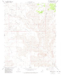
1981 Map of Tibbet Bench
USGS Topo · Published 1981About this map
High plateau landscapes and deep drainage systems define this 1981 survey of Kane County. The terrain is characterized by a series of prominent elevated platforms, including John Henry Bench, Tibbet Bench, and Nipple Bench, which overlook the complex network of Wesses Canyon and Tibbet Canyon. Water sources are vital landmarks in this arid environment, with several identified springs such as John Henry Spring, Clints Spring, and Tibbet Spring providing critical reference points for the region. The southeastern portion of the map transitions into the Glen Canyon National Recreation Area, where the topography descends toward Warm Creek and Baldwin Hollow. A single Mine located near Smoky Mountain suggests localized resource extraction amidst the vast natural landforms of the Colorado Plateau.
Find a feature on this map
20 named features on this map. Tap any name to fly to it.
Don’t see what you’re looking for? This feature index may not catch every label — zoom into the map to look around manually.
Map Details
Editions of this 1981 Tibbet Bench Map
This is the sole edition of this map. No revisions or reprints were ever made.
Other maps of this area

1886 · Escalante
USGS Topo · 1:250,000

1922 · Warm Creek
USGS Topo · 1:63,360

1922 · Upper Last Chance
USGS Topo · 1:63,360

1922 · Rees Canyon
USGS Topo · 1:63,360

1953 · Nipple Butte
USGS Topo · 1:62,500

1953 · Gunsight Butte
USGS Topo · 1:62,500

1956 · Escalante
USGS Topo · 1:250,000

1960 · Escalante
USGS Topo · 1:250,000

1968 · Fourmile Bench
USGS Topo · 1:24,000
1968 · Ship Mountain Point
USGS Topo · 1:24,000