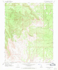
1968 Map of Ship Mountain Point
USGS Topo · Published 1971About this map
Ship Mountain Point rises as a central landmark in this 1968 study of Kane County's high desert landscape. The map details a complex network of plateaus and drainage systems, defined by the broad expanses of Fourmile Bench and John Henry Bench. This area of southern Utah is characterized by its steep-walled canyons, including Wesses Canyon and Clints Canyon, which feed into the Last Chance Creek watershed. Significant geological formations such as Pilot Rock and Pilot Knoll stand out as navigational aids in a region where water sources like Drip Tank were essential for movement. The southern portion of the sheet is dominated by the northern reaches of Smoky Mountain, while the name Dirty Devil appears in the lower drainage, reflecting the stark and challenging nature of the terrain as it was recorded during the late 1960s.
Find a feature on this map
17 named features on this map. Tap any name to fly to it.
Don’t see what you’re looking for? This feature index may not catch every label — zoom into the map to look around manually.
Map Details
Editions of this 1968 Ship Mountain Point Map
2 editions found
Other maps of this area

1886 · Escalante
USGS Topo · 1:250,000

1922 · Warm Creek
USGS Topo · 1:63,360

1922 · Upper Last Chance
USGS Topo · 1:63,360

1922 · Rees Canyon
USGS Topo · 1:63,360

1953 · Nipple Butte
USGS Topo · 1:62,500

1953 · Gunsight Butte
USGS Topo · 1:62,500

1956 · Escalante
USGS Topo · 1:250,000

1960 · Escalante
USGS Topo · 1:250,000

1968 · Fourmile Bench
USGS Topo · 1:24,000
1968 · Petes Cove
USGS Topo · 1:24,000