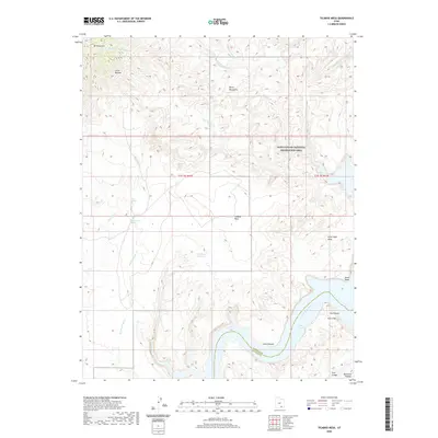
2020 Map of Ticaboo Mesa
USGS Topo · Published 2020About this map
Mt Ellsworth and the Little Rockies dominate the northwestern corner of this landscape, marking the southeastern extent of the Henry Mountains. This portion of Glen Canyon National Recreation Area is defined by a complex drainage system where the Middle Fork Ticaboo Cr, S Fork Ticaboo Cr, and Pesh-liki-Fork converge toward the Colorado River. The mapping shows the stark transition from high mesas like Ticaboo Mesa and Good Hope Mesa down to the flooded canyons of Lake Powell. Isolated water sources such as Ticaboo Shelf Spring, Colt Spring, and Wild Horse Spring indicate the critical points for travel and survival in this arid environment. The presence of the Ticaboo Reservoir and the naming of Good Hope reflect the history of resource management and early settlement attempts near the river's edge, while The Rincon highlights a distinctive geological cutoff meander along the canyon walls.
Find a feature on this map
30 named features on this map. Tap any name to fly to it.
Don’t see what you’re looking for? This feature index may not catch every label — zoom into the map to look around manually.
Map Details
Editions of this 2020 Ticaboo Mesa Map
This is the sole edition of this map. No revisions or reprints were ever made.
Other maps of this area

1886 · Henry Mountains
USGS Topo · 1:250,000

1892 · Henry Mountains
USGS Topo · 1:250,000

1952 · Mt Pennell 1 SW
USGS Topo · 1:24,000

1952 · Mancos Mesa
USGS Topo · 1:62,500

1952 · Mt Hillers
USGS Topo · 1:62,500

1952 · Mt Pennell 1 SE
USGS Topo · 1:24,000

1952 · Hite
USGS Topo · 1:62,500

1953 · Mt Pennell 4 NE
USGS Topo · 1:24,000

1953 · Mt. Ellsworth
USGS Topo · 1:62,500

1954 · White Canyon 3 NW
USGS Topo · 1:24,000