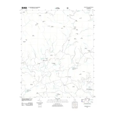
2011 Map of Tickanetley
USGS Topo · Published 2011About this map
Tickanetley sits at the heart of this North Georgia terrain, where the waters of the Cartecay River and Tickanetley Creek have shaped the settlement patterns of eastern Gilmer County. In 2011, this landscape was defined by its network of mountain gaps and small, scattered communities like Diamond, Quill, and Rolston. The geography is heavily influenced by water management, visible in the series of watershed structures such as Cartecay Watershed Dam Number One and Cartecay River Watershed Structure Number Five Dam, which created local landmarks like Garland Lake and Diamond Lake. Genealogists will find significant value in the documentation of local burial sites, including the Pisgah Cemetery, Macedonia Cemetery, and Scrougetown Cemetery. From the heights of Tickanetley Bald to the family-named landmarks like Marion Clayton Mountain and Kimmons Mountain, the map reveals a region where high ridges and deep gaps, such as Hardslate Gap and Doublehead Gap, dictate the winding paths of rural roads.
Find a feature on this map
101 named features on this map. Tap any name to fly to it.
Don’t see what you’re looking for? This feature index may not catch every label — zoom into the map to look around manually.
Map Details
Editions of this 2011 Tickanetley Map
This is the sole edition of this map. No revisions or reprints were ever made.
Other maps of this area

1888 · Ellijay
USGS Topo · 1:125,000

1892 · Ellijay
USGS Topo · 1:125,000

1898 · Ellijay
USGS Topo · 1:125,000

1911 · Ellijay
USGS Topo · 1:125,000

1935 · Noontootla
USGS Topo · 1:24,000
1935 · Cashes Valley
USGS Topo · 1:24,000

1935 · Lake Toccoa
USGS Topo · 1:24,000

1935 · Tickanetley
USGS Topo · 1:24,000
1935 · Wilscot
USGS Topo · 1:24,000
1946 · Tickanetley
USGS Topo · 1:24,000