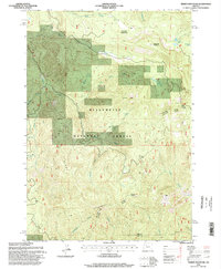
1994 Map of Tidbits Mountain
USGS Topo · Published 1998About this map
Willamette National Forest encompasses the entirety of this 1990s landscape, which centers on the high-elevation terrain of the Cascade Range. The map details a complex drainage system where Tidbits Creek and Elbow Creek feed into the Calapooia River in the southern sector, while north-flowing waters like Falls Creek and Two Girls Creek carve through the timbered slopes. The presence of multiple quarries scattered throughout the Forest Service land reflects the area's history of road building and resource management within the Sweet Home Ranger District. Prominent landmarks such as Tidbits Mountain and Soapgrass Mountain define the skyline, while smaller features like Gordon Meadows and Lost Lake provide specific points of reference for those tracing the trail systems and logging routes that stitch together the boundary between Linn and Lane counties.
Find a feature on this map
26 named features on this map. Tap any name to fly to it.
Don’t see what you’re looking for? This feature index may not catch every label — zoom into the map to look around manually.
Map Details
Editions of this 1994 Tidbits Mountain Map
This is the sole edition of this map. No revisions or reprints were ever made.
Other maps of this area

1934 · Mc Kenzie Bridge
USGS Topo · 1:96,000

1940 · Mc Kenzie Bridge
USGS Topo · 1:125,000

1953 · Salem
USGS Topo · 1:250,000

1954 · Salem
USGS Topo · 1:250,000

1955 · Blue River
USGS Topo · 1:62,500

1955 · Cascadia
USGS Topo · 1:62,500

1955 · Echo Mountain
USGS Topo · 1:62,500

1955 · Mc Kenzie Bridge
USGS Topo · 1:62,500

1960 · Salem
USGS Topo · 1:250,000

1962 · Salem
USGS Topo · 1:250,000