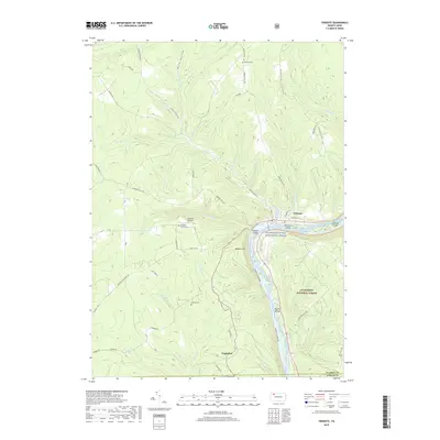
2019 Map of Tidioute
USGS Topo · Published 2019About this map
Tidioute sits at a prominent bend in the Allegheny Wild and Scenic River, where the town's grid meets the water's edge at Tidioute Island. This portion of the Allegheny National Forest is defined by a dense network of creek-cut terrain, featuring steep climbs toward Babylon Hill and numerous islands including McGuire Island and Siggias Island. Small cemeteries such as Morrison Cem, Swedish Union Cem, and Gorman Cem are tucked away on high ground, marking the heritage of rural residents and early settlers. To the south, the settlement of Fagundus serves as a waypoint along W Hickory Cr, while Rigtona Airport provides a clear landmark on the plateau above the river valley. The landscape is interconnected by historic routes like Campbell Hill Rd and Tidioute Creek Rd, tracing the paths of the many runs and creeks that feed the Allegheny.
Find a feature on this map
63 named features on this map. Tap any name to fly to it.
Don’t see what you’re looking for? This feature index may not catch every label — zoom into the map to look around manually.
Map Details
Editions of this 2019 Tidioute Map
This is the sole edition of this map. No revisions or reprints were ever made.
Other maps of this area

1926 · Youngsville
USGS Topo · 1:62,500

1927 · Tidioute
USGS Topo · 1:48,000

1927 · Titusville
USGS Topo · 1:62,500

1929 · Corry
USGS Topo · 1:48,000

1929 · Youngsville
USGS Topo · 1:62,500

1930 · Tidioute
USGS Topo · 1:62,500

1932 · Corry
USGS Topo · 1:62,500

1933 · Titusville
USGS Topo · 1:62,500

1943 · Youngsville
USGS Topo · 1:62,500

1957 · Warren
USGS Topo · 1:250,000