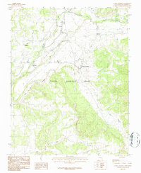
1983 Map of Tierra Amarilla
USGS Topo · Published 1987About this map
Tierra Amarilla Grant encompasses this high northern plateau, where the Rio Chama and its tributaries carve through the landscape. This 1983 edition details a network of historic settlements including Tierra Amarilla, Los Ojos, and La Puente, which are connected by early rural roads and water management features like the Park View Ditch. The geography is defined by the water of the Rio Brazos and Brazos Creek to the north, flowing toward the valley floors where agricultural activity is indicated by numerous irrigation lines and scattered Gravel Pits. Local landmarks such as the Ath Field and Radio Tower in the town of Tierra Amarilla provide specific points of reference for those researching the community's late twentieth-century development. Smaller hamlets like Plaza Blanca and Ensenada are shown with their proximity to cemetery grounds, labeled simply as Cem, reflecting the deep roots of families in the valley.
Find a feature on this map
21 named features on this map. Tap any name to fly to it.
Don’t see what you’re looking for? This feature index may not catch every label — zoom into the map to look around manually.
Map Details
Editions of this 1983 Tierra Amarilla Map
2 editions found
Other maps of this area

1918 · Tusas
USGS Topo · 1:125,000

1954 · Aztec
USGS Topo · 1:250,000

1955 · Chama
USGS Topo · 1:62,500

1955 · Cebolla
USGS Topo · 1:62,500

1955 · Brazos Peak
USGS Topo · 1:62,500

1955 · Tierra Amarilla
USGS Topo · 1:62,500

1958 · Aztec
USGS Topo · 1:250,000

1962 · Aztec
USGS Topo · 1:250,000

1965 · Aztec
USGS Topo · 1:250,000

1981 · Chama
USGS Topo · 1:100,000