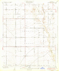
1933 Map of Tierra Bonita
USGS Topo · Published 1933About this map
Antelope Valley appears here as a landscape of grid-patterned roads and dispersed homesteads in the early 1930s. The surveyor F. K. Van Zandt documented this arid portion of the High Desert during a period of transition, where established infrastructure like the Tierra Bonita Sch served a community of scattered desert ranches. The map reveals the vital importance of water in this environment, marking several instances of a Well and the prominent Little Rock Wash cutting across the eastern plains. These features highlight the early challenges of settlement before the expansion of modern irrigation and suburbanization. Cultural landmarks such as the Twin Joshua Rancho and the sequential road network from J Avenue down to P Avenue show the rigid geometric order imposed upon the natural desert terrain by Los Angeles County planners during this era.
Find a feature on this map
15 named features on this map. Tap any name to fly to it.
Don’t see what you’re looking for? This feature index may not catch every label — zoom into the map to look around manually.
Map Details
Editions of this 1933 Tierra Bonita Map
3 editions found
Other maps of this area

1915 · Elizabeth Lake
USGS Topo · 1:125,000

1917 · Elizabeth Lake
USGS Topo · 1:125,000

1930 · Oban
USGS Topo · 1:24,000

1930 · Roosevelt School
USGS Topo · 1:24,000

1930 · Little Rock
USGS Topo · 1:24,000

1930 · Casa Desierta
USGS Topo · 1:24,000

1930 · Lancaster
USGS Topo · 1:24,000

1930 · Pearland
USGS Topo · 1:24,000

1930 · West Alpine Butte
USGS Topo · 1:24,000

1930 · Tierra Bonita
USGS Topo · 1:24,000