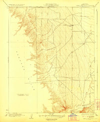
1923 Map of Tierra Loma School
USGS Topo · Published 1923About this map
The Tierra Loma School stands as a lonely point of civic infrastructure in this 1920s landscape on the western edge of the San Joaquin Valley. Situated at the base of the Panoche Hills, the schoolhouse serves a network of section lines and faint trails that crisscross the arid flats. This preliminary survey by Department of the Interior engineers reveals a sharp contrast between the organized grid of the valley floor and the rugged, unsurveyed terrain to the west. To the south, Panoche Creek winds through the landscape, providing a critical natural landmark in an area otherwise defined by its sparse settlement and the transitional zone where the alluvial plains meet the rising hills of the Coast Ranges.
Find a feature on this map
4 named features on this map. Tap any name to fly to it.
Don’t see what you’re looking for? This feature index may not catch every label — zoom into the map to look around manually.
Map Details
Editions of this 1923 Tierra Loma School Map
2 editions found
Other maps of this area

1913 · Panoche
USGS Topo · 1:125,000

1921 · Laguna Seca Ranch
USGS Topo · 1:31,680

1921 · Tierra Loma School
USGS Topo · 1:31,680

1922 · Chaney Ranch
USGS Topo · 1:31,680

1923 · Laguna Seca Ranch
USGS Topo · 1:31,680

1923 · Wisdom Well
USGS Topo · 1:31,680

1923 · Tierra Loma School
USGS Topo · 1:31,680

1923 · Little Panoche
USGS Topo · 1:31,680

1923 · Monocline Ridge
USGS Topo · 1:31,680

1943 · Ortigalita Peak
USGS Topo · 1:62,500