
1923 Map of Tierra Loma School
USGS Topo · Published 1923About this map
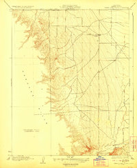
Tierra Loma School stands as a focal point on this 1920s survey of the western San Joaquin Valley, situated at the base of the dramatic Panoche Hills. The landscape is defined by the sharp transition from the steep, corrugated topography of the hills to the broad, alluvial plains of Fresno County. This particular edition includes a large Western section marked as a Preliminary Edition Unsurveyed Area, reflecting the ongoing efforts by topographic engineers like R.A. Kiger and Adolph Fankhauser to document the California interior. The seasonal drainage of Panoche Creek winds through the southern portion of the sheet, tracing a path across the flats that would have been critical for early ranching and settlement patterns in this arid region before modern water management transformed the valley.
Find a feature on this map
4 named features on this map. Tap any name to fly to it.
Don’t see what you’re looking for? This feature index may not catch every label — zoom into the map to look around manually.
Map Details
Editions of this 1923 Tierra Loma School Map
2 editions found
Other maps of this area

1913 · Panoche
USGS Topo · 1:125,000

1921 · Laguna Seca Ranch
USGS Topo · 1:31,680

1921 · Tierra Loma School
USGS Topo · 1:31,680

1922 · Chaney Ranch
USGS Topo · 1:31,680

1923 · Laguna Seca Ranch
USGS Topo · 1:31,680

1923 · Wisdom Well
USGS Topo · 1:31,680

1923 · Little Panoche
USGS Topo · 1:31,680

1923 · Monocline Ridge
USGS Topo · 1:31,680

1943 · Ortigalita Peak
USGS Topo · 1:62,500

1944 · Panoche Valley
USGS Topo · 1:62,500