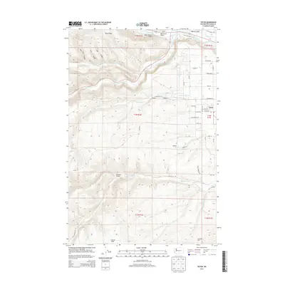
2014 Map of Tieton
USGS Topo · Published 2014About this map
Tieton serves as the primary hub of this Yakima County landscape, where the orchard-lined streets of Tieton Ave and Naches Ave meet the surrounding agricultural infrastructure. The topography is defined by the descent from Bethel Ridge toward the Upper Naches Valley, with the Naches River and Tieton River carving significant paths through the terrain. A complex irrigation network, including the Wapatox Canal and various laterals like Lateral A and Lateral E, demonstrates the area's long-standing dependence on water management for its fruit-growing economy.
Find a feature on this map
56 named features on this map. Tap any name to fly to it.
Don’t see what you’re looking for? This feature index may not catch every label — zoom into the map to look around manually.
Map Details
Editions of this 2014 Tieton Map
This is the sole edition of this map. No revisions or reprints were ever made.
Other maps of this area

1899 · Ellensburg
USGS Topo · 1:125,000

1901 · Ellensburg
USGS Topo · 1:125,000

1950 · Yakima
USGS Topo · 1:250,000

1958 · Ellensburg
USGS Topo · 1:62,500

1958 · Wiley City
USGS Topo · 1:24,000

1958 · Naches
USGS Topo · 1:24,000

1958 · Yakima
USGS Topo · 1:250,000

1961 · Yakima
USGS Topo · 1:250,000

1971 · Nile
USGS Topo · 1:24,000
1971 · Milk Canyon
USGS Topo · 1:24,000