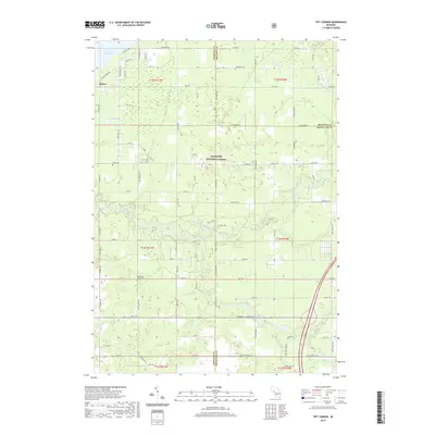
2019 Map of Tift Corner
USGS Topo · Published 2019About this map
Manistee National Forest covers much of this landscape in West Michigan, where the edges of Newaygo, Mecosta, and Montcalm counties converge. The topography is defined by the waters of Hardy Dam Pond and the small settlement of Oxbow in the northwest. Local history and genealogy are anchored by several distinct burial grounds, including Prairie Cem near the junction of 56th St and E 56th St, Gulp Cem, and the Christian Plains Cem further south. The map reflects a rural grid of section-line roads, such as Tamarack Rd and Howard City Edmore Rd, which cut through the forested and creek-bottom lands. Natural drainage patterns are evident around Tucker Lake and the various tributaries that flow through the timbered sections of the national forest.
Find a feature on this map
53 named features on this map. Tap any name to fly to it.
Don’t see what you’re looking for? This feature index may not catch every label — zoom into the map to look around manually.
Map Details
Editions of this 2019 Tift Corner Map
This is the sole edition of this map. No revisions or reprints were ever made.
Other maps of this area

1954 · Midland
USGS Topo · 1:250,000

1958 · Midland
USGS Topo · 1:250,000

1958 · Sand Lake
USGS Topo · 1:62,500

1958 · Woodville
USGS Topo · 1:62,500

1958 · Big Rapids
USGS Topo · 1:62,500

1959 · Midland
USGS Topo · 1:250,000

1959 · Howard City
USGS Topo · 1:62,500

1966 · Midland
USGS Topo · 1:250,000

1976 · Big Rapids SW
USGS Topo · 1:24,000
1976 · Howard City NW
USGS Topo · 1:24,000