1959 Map of Tigerville
USGS Topo · Published 1963About this map
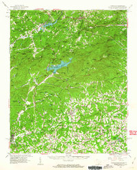
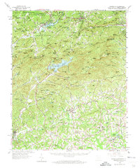
The Blue Ridge Mountains and the Saluda Mountains dominate this 1959 survey of the borderlands between North Carolina and South Carolina. This landscape is defined by the critical watershed of the North Saluda River, which feeds the central Poinsett Reservoir, a significant infrastructure feature for the Greenville area. The map captures the region’s mid-century educational and institutional growth, anchored by North Greenville Junior College at Tigerville. To the north, the Southern railroad connects Zirconia and Saluda, traversing the steep grade of the Hendersonville Ridge Divide. Family and community life is visible in the network of country churches like Mush Creek Ch and New Salem Ch, while the region's economy is represented by the State Fish Hatchery and recreational nodes like Pleasant Ridge State Park.
Find a feature on this map
166 named features on this map. Tap any name to fly to it.
Don’t see what you’re looking for? This feature index may not catch every label — zoom into the map to look around manually.
Map Details
Editions of this 1959 Tigerville Map
2 editions found
Other maps of this area

1888 · Pickens
USGS Topo · 1:125,000

1894 · Pickens
USGS Topo · 1:125,000

1905 · Pisgah
USGS Topo · 1:125,000

1906 · Pisgah
USGS Topo · 1:125,000

1907 · Saluda
USGS Topo · 1:125,000

1935 · Standingstone Mtn.
USGS Topo · 1:24,000

1935 · Greer
USGS Topo · 1:48,000

1935 · Horse Shoe
USGS Topo · 1:24,000

1935 · Hendersonville
USGS Topo · 1:24,000

1935 · Greenville
USGS Topo · 1:48,000