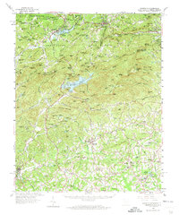
1959 Map of Tigerville
USGS Topo · Published 1973About this map
The Blue Ridge Divide and Saluda Mountains dominate this 1959 survey of the borderlands between North and South Carolina. High-elevation settlements such as Tuxedo and Zirconia are linked by the Southern railroad, while the rugged topography below is defined by the headwaters of the North Pacolet River, North Saluda River, and the various forks of the Tyger River. Significant water management and recreational features are evident at the Lake Summit dam and the Poinsett Reservoir, which sits south of Corbin Mtn. In the lower elevations of Greenville County, Tigerville is established around the North Greenville Junior College campus. The map reveals a rural landscape dotted with local landmarks like Mount Olive Ch, Barton Chapel, and the State Fish Hatchery, alongside industrial footprints like the textile-adjacent community of Slater.
Find a feature on this map
151 named features on this map. Tap any name to fly to it.
Don’t see what you’re looking for? This feature index may not catch every label — zoom into the map to look around manually.
Map Details
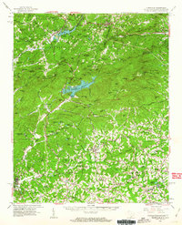
Editions of this 1959 Tigerville Map
2 editions found
Other maps of this area

1888 · Pickens
USGS Topo · 1:125,000

1894 · Pickens
USGS Topo · 1:125,000

1905 · Pisgah
USGS Topo · 1:125,000

1906 · Pisgah
USGS Topo · 1:125,000

1907 · Saluda
USGS Topo · 1:125,000

1935 · Standingstone Mtn.
USGS Topo · 1:24,000

1935 · Greer
USGS Topo · 1:48,000

1935 · Horse Shoe
USGS Topo · 1:24,000

1935 · Hendersonville
USGS Topo · 1:24,000

1935 · Greenville
USGS Topo · 1:48,000